Typhoon JENNY is less likely to directly bring heavy rainfall over the country throughout the forecast period.
Furthermore, the effect of the typhoon on the Southwest Monsoon has weakened, although the western section of Luzon may still experience some rain showers State Weather Bureau Pagasa said Friday.
However, the public is advised to refer to the 24-hour Public Weather Forecast and Outlook of Pagasa for weather monitoring purposes.
HAZARDS AFFECTING COASTAL WATERS
The Gale Warning for coastal waters has been lifted. Nevertheless, in the next 24 hours, JENNY may still bring moderate to rough seas (1.5 to 3.0 m) over the coastal waters of Batanes, the western portion of Babuyan Islands, Ilocos Norte, and Ilocos Sur. Mariners of motor bancas and similarly-sized vessels are advised to take precautionary measures while venturing out to sea and, if possible, avoid navigating in these conditions, especially if inexperienced or operating ill-equipped vessels.
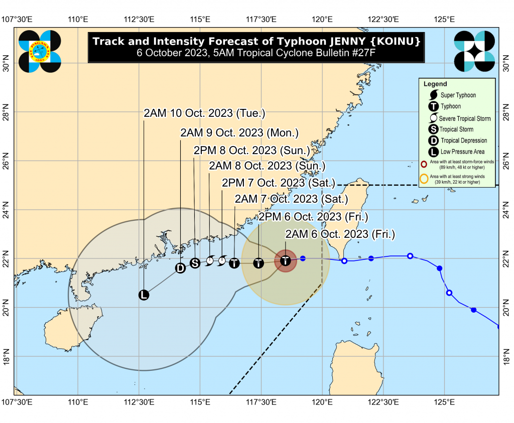
TRACK AND INTENSITY OUTLOOK
Outside the PAR region, JENNY will continue to move westward (becoming west-southwestward to southwestward by Sunday) slowly over the coastal waters of southeastern China.
JENNY is forecast to remain a typhoon until today or early tomorrow (Saturday) before entering a sustained weakening trend. The typhoon is forecast to become a remnant low by late Monday or early Tuesday.
Location of Eye/center
The center of the eye was estimated based on all available data 385 km West Northwest of Itbayat, Batanes (OUTSIDE PAR) (21.8 °N, 118.3 °E )
Movement
Moving Westward at 10 km/h
Strength
Maximum sustained winds of 120 km/h near the center and gustiness of up to 150 km/h
Forecast Position
Oct 06, 2023 02:00 PM – 475 km West Northwest of Itbayat, Batanes (OUTSIDE PAR)
Oct 07, 2023 02:00 AM – 575 km West Northwest of Itbayat, Batanes (OUTSIDE PAR)
Oct 07, 2023 02:00 PM – 630 km West Northwest of Itbayat, Batanes (OUTSIDE PAR)
Oct 08, 2023 02:00 AM – 680 km Northwest of Laoag City, Ilocos Norte (OUTSIDE PAR)
Oct 08, 2023 02:00 PM – 720 km Northwest of Laoag City, Ilocos Norte (OUTSIDE PAR)
Oct 09, 2023 02:00 AM – 765 km West Northwest of Laoag City, Ilocos Norte (OUTSIDE PAR)
Oct 10, 2023 02:00 AM – 860 km West Northwest of Northern Luzon (OUTSIDE PAR)
No Tropical Cyclone Wind Signal
Considering these developments, the public and disaster risk reduction and management offices concerned are advised to take all necessary measures to protect life and property.
Persons living in areas identified to be highly or very highly susceptible to these hazards are advised to follow evacuation and other instructions from local officials.
For heavy rainfall warnings, thunderstorm/rainfall advisories, and other severe weather information specific to your area, the public is advised to monitor products issued by the local PAGASA Regional Services Division.
(Filed by Jr Amigo/ai/mnm)