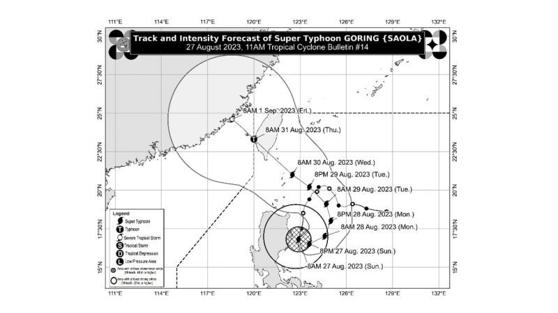
MANILA — Goring has rapidly intensified into a super typhoon as of Sunday morning, poised to unleash heavy rainfall across extensive regions of the country, according to the national meteorological agency.
As of 4 a.m., Goring was located above the coastal waters of Palanan, Isabela. It has gained maximum sustained winds of 185 kilometers per hour near its center, with gusts reaching up to 230 kph, as indicated by PAGASA.
This super typhoon is projected to deliver an accumulated rainfall exceeding 200 mm, equivalent to nearly 8 inches, across the far eastern stretch of Isabela on Sunday, as forecasted by the weather authority.
The eastern parts of mainland Cagayan and Isabela will experience a rainfall range of 100-200 mm (approximately 4 to 8 inches), while the Ilocos Region, Apayao, Abra, Benguet, the northern sector of Aurora, the eastern sector of Nueva Vizcaya, and the remaining parts of mainland Cagayan and Isabela should anticipate 50 to 100 mm (around 2 to 4 inches) of rainfall.
The weather forecaster cautioned that these conditions could lead to flooding and rain-triggered landslides, especially in areas highly susceptible to such hazards.
Goring will also enhance the southwest monsoon, ushering in intermittent rains across the western areas of Central Luzon, Southern Luzon, and Visayas over the ensuing three days, as detailed by PAGASA.
In its 5 a.m. advisory, PAGASA raised tropical cyclone wind signal no. 3 over the far eastern segment of Isabela (Divilacan, Palanan), with these locales expected to encounter winds of 89 to 117 kph over a span of at least 18 hours.
PAGASA also issued the subsequent wind signals:
SIGNAL NO. 2
Eastern segment of mainland Cagayan (Peñablanca, Baggao, Gattaran, Lal-Lo, Gonzaga, Santa Teresita, Buguey, Santa Ana)
Eastern segment of Isabela (Dinapigue, Ilagan City, Maconacon, Cabagan, Tumauini, San Pablo, Benito Soliven, San Mariano)
Extreme northern portion of Aurora (Dilasag, Casiguran)
SIGNAL NO. 1
Babuyan Islands
Remaining parts of mainland Cagayan
Remaining parts of Isabela
Quirino
Nueva Vizcaya
Apayao
Kalinga
Abra
Mountain Province
Ifugao
Eastern segment of Benguet (Bokod, Buguias, Kabayan, Mankayan)
Eastern segment of Ilocos Norte (Pagudpud, Adams, Vintar, Carasi, Nueva Era, Banna, Marcos, Dingras, Solsona, Piddig, Dumalneg, Bangui)
Northeastern segment of Nueva Ecija (Carranglan, Pantabangan, Bongabon, Gabaldon, Laur, Rizal)
Northern and central segments of Aurora (Dinalungan, Dipaculao, Baler, Maria Aurora, San Luis)
Polillo Islands
Calaguas Islands
Goring is anticipated to initiate a looping trajectory over the Philippine Sea to the east of the Cagayan-Isabela region on Sunday. Subsequently, the super typhoon will veer northeastward and then northward on Monday, followed by a shift towards a more northwestward path on Tuesday, according to PAGASA’s projections.
By Wednesday evening or Thursday morning, Goring is projected to make landfall over the southern portion of Taiwan.”
(AI/MNM)