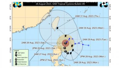
MANILA — The weather disturbance known as “Goring” (internationally named: Saola) has intensified, now classified as a tropical storm. As of Thursday, it is moving in a northwestward direction across the Philippine Sea, according to the latest report from the state weather bureau.
In the 5 p.m. weather bulletin, PAGASA announced that Goring’s current position is 265 kilometers east of Basco, Batanes. It possesses maximum sustained winds of 75 kilometers per hour near its center, accompanied by gusts reaching up to 90 kph.
Currently, the storm’s movement is northwestward at a pace of 10 kph. The forecast indicates that it will veer towards the west-southwest before curving southward over the waters along the eastern side of Cagayan Valley.
PAGASA’s projection suggests that over the upcoming five days, Goring will chart a generally looping trajectory, potentially resuming a more northward course by late Monday or Tuesday of next week.
Preparations for potential tropical cyclone wind signals across northern Luzon are set to commence on Thursday night or Friday, as noted by PAGASA.
While Goring is not expected to bring widespread heavy rainfall to the country in the next three days, its proximity to land could lead to substantial rainfall in parts of Cagayan Valley over the same period. This occurrence would be contingent on any westward deviation in the storm’s path, as highlighted by PAGASA. (ai/mnm)