MANILA – Southwest monsoon or “habagat” enhanced by Typhoon Hanna will bring moderate to heavy rainfall over Metro Manila, the western portion of Luzon and Antique in the next three days, the Philippine Atmospheric, Geophysical and Astronomical Services Administration (PAGASA) said Sunday.
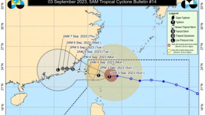
PAGASA said Hanna slightly intensified as it moves closer to the coast of southern Taiwan.
In its 5 a.m. bulletin, the weather bureau said the center of the eye of Hanna was estimated at 215 kilometers north northeast of Itbayat, Batanes with maximum sustained winds of 150 kilometers per hour (kph) near the center and gustiness of up to 185 kph.
Batanes and the northern portion of Babuyan Islands are under Tropical Cyclone Wind Signal No. 1.
A gale warning is in effect for the northern and western seaboards of Luzon, the eastern seaboards of Central and Southern Luzon, portions of seaboards of northern Quezon, the southern seaboard of Southern Luzon, and the western seaboard of Visayas due to the combined influence of Hanna and the enhanced southwest monsoon, PAGASA said.
“Minimal to minor impacts from strong winds are also possible within any of the areas under Wind Signal No. 1,” the weather advisory added.
It said Hanna may exit the Philippine Area of Responsibility late Sunday evening or Monday morning as a severe tropical storm.
Hanna, however, will continue to enhance southwest monsoon that will bring occasional to monsoon rains in Ilocos Region, Zambales, Bataan, Occidental Mindoro, Metro Manila, Abra, Apayao, Benguet, Tarlac, Pampanga, Bulacan, Rizal, Cavite, and Batangas.
Western Visayas and the rest of Luzon will have cloudy skies with scattered rain showers and thunderstorms also due to the southwest monsoon.
The rest of the country will experience partly cloudy to cloudy skies with isolated rain showers or thunderstorms due to southwest monsoon and localized thunderstorms.
PAGASA warned that flooding and rain-induced landslides are possible due to heavy to at times intense or heavy rains. (PNA)


